Category: Places

  • Eye of Sahara, the Richat Structure

    Eye of Sahara, the Richat Structure

    Eye of Sahara, the Richat Structure

    Perhaps the greatest unsolved natural mystery is what is the “eye of Sahara” and how did it get there? Such a gorgeous structure too, that it has it’s own Pinterest Boards and been blogged, researched, debunked, reported on and talked about for decades. To this day, there’s no explanation for who’s eye it is.

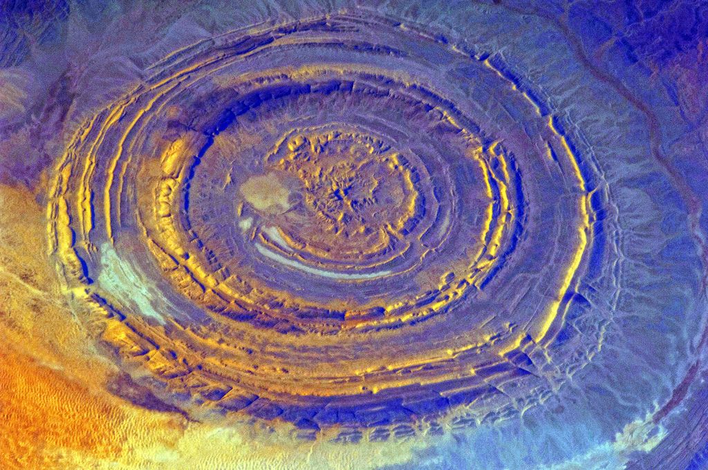
    The Richat Structure, also called the “Eye of Africa”, or “Eye of the Sahara” is a prominent circular feature in the Sahara‘s Adrar Plateau, near Ouadane, west–central Mauritania.

    A topographic reconstruction (scaled 6:1 on the vertical axis) from satellite photos. False coloring as follows: • Brown: bedrock • Yellow/white: sand • Green: vegetation • Blue: salty sediments
    A topographic reconstruction (scaled 6:1 on the vertical axis) from satellite photos. False coloring as follows: • Brown: bedrock • Yellow/white: sand • Green: vegetation • Blue: salty sediments

    Naughty Beaver believes this to be a crashed UFO and if you look at the evidence, there’s no doubt that makes sense. Also, it would explain why civilization began from that point on the planet and who built the pyramids, and if they used the pyramids to generate enough energy to leave, then it would explain why we don’t know who put the pyramids there.

    NASA tries to explain what happened on September 9, 2018 by issuing a statement that there were two lunar transits passing in front of the sun.
    NASA’s Solar Dynamics Observatory, SDO photo from September 9, 2018
    NASA’s Solar Dynamics Observatory, SDO photo from September 9, 2018

    Lunar Transit or huge disk-shaped UFO?

    “On Sept. 9, 2018, NASA’s Solar Dynamics Observatory, SDO, saw two lunar transits as the Moon passed in front of the Sun. A transit happens when a celestial body passes between a larger body and an observer.

    The Moon does not, of course, actually change direction, but it appears to do so from SDO’s perspective based on the fact that the spacecraft’s orbit essentially catches up and passes the Moon during the first transit.”

    Here’s some of what we do know about The Eye of Sahara.

    Eye of Sahara - Satellite picture of the Richat Structure (false colour)
    Satellite picture of the Richat Structure (false colour)

    The Richat Structure is a deeply eroded, slightly elliptical dome with a diameter of 40 kilometres (25 mi). The sedimentary rock exposed in this dome ranges in age from Late Proterozoic within the center of the dome to Ordovician sandstone around its edges. The sedimentary rocks composing this structure dip outward at 10–20°. Differential erosion of resistant layers of quartzite has created high-relief circular cuestas. Its center consists of a siliceous breccia covering an area that is at least 30 kilometres (19 mi) in diameter.

    Getting to this place is extremely challenging. Have a look at the terrain.

    Exposed within the interior of the Richat Structure are a variety of intrusive and extrusive igneous rocks. They include rhyolitic volcanic rocks, gabbros, carbonatites and kimberlites. The rhyolitic rocks consist of lava flows and hydrothermally altered tuffaceous rocks that are part of two distinct eruptive centers, which are interpreted to be the eroded remains of two maars. According to field mapping and aeromagnetic data, the gabbroic rocks form two concentric ring dikes. The inner ring dike is about 20 m in width and lies about 3 km from the center of the Richat Structure. The outer ring dike is about 50 m in width and lies about 7 to 8 km from the center of this structure. Thirty-two carbonatite dikes and sills have been mapped within the Richat Structure. The dikes are generally about 300 m long and typically 1 to 4 m wide. They consist of massive carbonatites that are mostly devoid of vesicles. The carbonatite rocks have been dated as having cooled between 94 and 104 million years ago. A kimberlitic plug and several sills have been found within the northern part of the Richat Structure. The kimberlite plug has been dated to around 99 million years old. These intrusive igneous rocks are interpreted as indicating the presence of a large alkaline igneous intrusion that currently underlies the Richat Structure and created it by uplifting the overlying rock.

    Spectacular hydrothermal features are a part of the Richat Structure. They include the extensive hydrothermal alteration of rhyolites and gabbros and a central megabreccia created by hydrothermal dissolution and collapse. The siliceous megabreccia is at least 40 m thick in its center to only a few meters thick along its edges. The breccia consists of fragments of white to dark gray cherty material, quartz-rich sandstone, diagenetic cherty nodules, and stromatolitic limestone and is intensively silicified. The hydrothermal alteration, which created this breccia, has been dated to have occurred about 98.2 ± 2.6 million years ago using the 40Ar/39Ar method.

    Interpretation

    The Richat structure is regarded by geologists as a highly symmetrical and deeply eroded geologic dome. It was first described in the 1930s to 1940s, as Richât Crater or Richât buttonhole (boutonnière du Richât). Richard-Molard (1948) considered it to be the result of a laccolithic thrust. A geological expedition to Mauritania led by Théodore Monod in 1952 recorded four “crateriform or circular irregularities” (accidents cratériformes ou circulaires) in the area, Er Richât, Aouelloul (south of Chinguetti), Temimichat-Ghallaman and Tenoumer. Origin of Er Richât as an impact structure (as is clearly the case with the other three) was briefly considered, but closer study in the 1950s to 1960s suggested that it was formed by terrestrial processes. After extensive field and laboratory studies in the 1960s, no credible evidence has been found for shock metamorphism or any type of deformation indicative of a hypervelocity extraterrestrial impact.  While coesite, an indicator of shock metamorphism, had initially been reported as being present in rock samples collected from the Richat Structure, further analysis of rock samples concluded that barite had been misidentified as coesite.

    Work on dating the structure was done in the 1990s.  Renewed study of the formation of the structure by Matton et al. (2005) and Matton (2008) confirmed the conclusion that it is not an impact structure. The circular distribution of ridges and valleys is explained as the formation of cuestas by the differential erosion of alternating hard and soft rock layers uplifted as a dome by an underlying alkaline igneous complex of Cretaceous age.

    A 2011 multianalytical study on the Richat megabreccias concluded that carbonates within the silica-rich megabreccias were created by low-temperature hydrothermal waters, and that the structure requires special protection and further investigation of its origin.

    Archaeology

    The Richat structure, also known as the Guelb er-Richât in the Mauritanian Adrar is the location of exceptional accumulations of Acheulean artifact. These Acheulean archaeological sites are located along wadis that occupy outermost annular depression of this structure. Pre-Acheulean stone tools also have been found in the same areas. These sites are associated with rubbly, chaotic outcrops of quartzite that provided the raw material needed for the manufacture of these artifacts. The most important Acheulean sites and their associated outcrops are found along the north-west of the outer ring, from which Wadi Akerdil heads east and Wadi Bamouere to the west. Sparse and widely scattered Neolithic spear points and other artifacts have also been found. However, since these sites were first discovered by Theodore Monod in 1974,  mapping of artifacts within the area of the Richat structure have found them to be generally absent in its innermost depressions. So far, neither recognizable midden deposits nor manmade structures have been recognized and reported from the Richat structure. This is interpreted as indicating that area of the Richat structure was used only for short-term hunting and stone tool manufacturing. The local, apparent wealth of surface artifacts is the result of the concentration and mixing by deflation over multiple glacialinterglacial cycles.

    Artifacts are found, typically redeposited, deflated, or both, in Late Pleistocene to early Holocene gravelly mud, muddy gravel, clayey sand, and silty sand. These sediments are often cemented into either concretionary masses or beds by calcrete. Ridges typically consist of deeply weathered bedrock representing truncated Cenozoic paleosols that formed under tropical environments. The Pleistocene to Middle Holocene sediments occur along wadis as thin, meter- to less than meter-thick accumulations in the interior annular depressions to 3–4 meters (9.8–13.1 ft) thick accumulations along the wadis in the outermost annular depression of the Richat structure. The gravelly deposits consist of mixture of slope scree, debris flow, and fluviatile or even torrential flow deposits. The finer grained, sandy deposits consist of eolian and playa lake deposits. The latter contain well-preserved, freshwater fossils. Numerous, concordant radiocarbon dates, indicate that the bulk of these sediments accumulated between 15,000 and 8,000 BP during the African humid period. These deposits lie directly upon deeply eroded and weathered bedrock.

    Eye of Sahara, the Richat Structure Source: Wikipedia

  • Orpheum Theatre for Easter Sunday

    Orpheum Theatre for Easter Sunday

    Orpheum Theatre Vancouver View Of Stage

    Thanks to Coastal Church of Vancouver for opening the doors of the Orpheum Theatre and entertaining us, and presenting such an awe inspiring Easter Sunday presentation.

    During the service we celebrated the resurrection of our Saviour with dynamic worship music, stories of real life change, special media, musical elements, and a powerful message from Pastor, David Koop.

     Easter Sunday Services  April 21st @ 9:30 AM & 12:30 PM at the Orpheum Theatre

    If you declare with your mouth, “Jesus is Lord,” and believe in your heart that God raised him from the dead, you will be saved.

    Romans 10:9

    The special musical presentation duet, of singer and violinist, backed by the orchestra was fabulous, especially from the best balcony seats in the house. Great show! I’m especially grateful for having seen the theatre in the daylight, to marvel at the ornate decor and purposeful design. This is truly a Vancouver Landmark building.

    Orpheum Theatre Vancouver

    The Orpheum Theatre with advertising for the movie Lady Luck, circa 1946.
    The Orpheum Theatre with advertising for the movie Lady Luck, circa 1946.

    The Orpheum is a theatre and music venue in Vancouver, British Columbia, Canada. Along with the Queen Elizabeth Theatre and the Vancouver Playhouse, it is part of the Vancouver Civic Theatres group of live performance venues. It is the permanent home of the Vancouver Symphony Orchestra. The Orpheum is located on Granville Street near Smithe Street in Vancouver’s downtown core. The interior of the theatre was featured prominently in the award-winning 2004 reboot of Battlestar Galactica, where it is dressed to portray a heavenly opera house.

    Designed by Scottish architect Marcus Priteca, the theatre officially opened on November 8, 1927 as a vaudeville house, but it hosted its first shows the previous day.  The old Orpheum, at 761 Granville Street, was renamed the Vancouver Theatre (later the Lyric, then the International Cinema, then the Lyric once more before it closed for demolition in 1969 to make way for the first phase of the Pacific Centre project). The New Orpheum, which was the biggest theatre in Canada when it opened in 1927, with three thousand seats, cost $1.25 million to construct. The first manager of the theatre was William A. Barnes.

    Following the end of vaudeville’s heyday in the early 1930s, the Orpheum became primarily a movie house under Famous Players ownership, although it would continue to host live events on occasion. Ivan Ackery managed the Orpheum during most of this period, from 1935 up until his 1969 retirement.[

    The Orpheum Theatre 2005, advertising the Vancouver Symphony Orchestra.
    The Orpheum Theatre 2005, advertising the Vancouver Symphony Orchestra.

    In 1973, for economic reasons, Famous Players decided to gut the inside of the Orpheum and change it into a multiplex. A “Save the Orpheum” public protest and fundraising campaign was launched, which even Jack Benny flew in to help with, and the Orpheum was saved. On March 19, 1974,  the City of Vancouver bought the theatre for $7.1 million, with $3.1 million coming from the city itself, and $1.5 million from each of the provincial and federal governments..  The Orpheum closed on November 23, 1975 and a renovation and restoration was done by the architectural company Thomson, Berwick, Pratt and Partners. It re-opened on April 2, 1977 and has since been the permanent home of the Vancouver Symphony Orchestra.  Tony Heinsbergen, a U.S. designer who originally chose the color scheme for the interior (ivory, moss green, gold and burgundy) was brought back, fifty years later, for the renovation. In 1983, an additional entrance was opened on Smithe Street.

    The theatre was designated a National Historic Site of Canada in 1979.

    In 2006, the Capitol Residences development was proposed for the old Capitol 6 cinema site adjacent to the Orpheum. The City of Vancouver gave the developer permission for extra height and density on their site in return for a major expansion to the Orpheum, including a long desired back stage area. This was the largest amenities trade in the history of the city, and will increase the usability of the facility.

    The Orpheum’s neon sign was donated by Jim Pattison in the 1970s.

    The theatre and its neon sign have been used as a key location in several episodes of the science-fiction series Battlestar Galactica and Fringe, as well as Highlander: The Series. It was also the location of the filming of the Dan Mangan documentary What Happens Next? by Brent Hodge.

    Orpheum Theatre Interior Photo credit: GoToVan on Visualhunt / CC BY

    Night photo of the Orpheum sign provided by Michael G. Khmelnitsky. http://www.mig81.com – Michael G. Khmelnitsk

  • Earth Day in the Pacific Northwest

    Earth Day in the Pacific Northwest

    Earth Day

    There’s no other day that deserves recognition and celebration like Earth Day, we don’t even know how old she is, or who lives inside her and on her sea floor but we managed to exploit every square inch of the place we call earth. Today I give thanks and declare my love of mother earth, the best planet that I’m able to remember living on.

    Sure we have moments of discomfort and occasional tremors, belches and quakes but no matter what we humans do to slow her down, she just keeps spinning around like we weren’t even here. Meanwhile we’re busy drilling holes and scraping the surface, poisoning and plundering with the sense of urgency of a tick on a dog, and yet she just keeps on flying through space, while playing in a band with nine other planets (Nibiru = X), in an endless series of concerts, while many of the passengers are busy planning a mutiny, of the people who they think, control the spin.

    In the great symphony of the planets, the little earth is just a singer in the chorus, as the tempo of the song accelerates and the beat quickens, the resonance raises as the climax approaches. Pulsating energy blasts out into space at a higher and higher frequency, as we all whirl through the universe together, towards the next dimension, on our way to infinity, faster and faster.

    The audience is in awe of the fractals, and wonders if she will do a pole reversals for an encore. Do we end at the beginning? or do we begin at the end? Are we inside a computer simulation, or is this the mind of God?

    Earth Day Network

    EARTH DAY NETWORK’S 2019 CLEANUP SPANS THOUSANDS OF LOCATIONS DURING APRIL

    Over 3,000 cleanups in communities across the U.S. for Earth Day 2019

    April 15, 2019 (Washington D.C.) – Earth Day Network is implementing a nationally coordinated environmental volunteer cleanup to mark Earth Day 2019, in collaboration with partners across the U.S., including National CleanUp Day and Keep America Beautiful. All over the country people are encouraged to get up, get out, and help clean their communities to celebrate Earth Day.

    People have a right to expect a clean environment and can exercise that right by helping to clean their own communities with over 3,000 cleanups of green spaces, urban landscapes and waterways with grassroots organizations leading up to Earth Day on April 22 and taking place throughout the remainder of the month of April.

    Volunteers across the U.S. are coming together with grassroots organizations for Earth Day 2019 to clean up over 3,000 green spaces, urban landscapes, and waterways. Plastic pollution and waste challenge every community, every day, and these cleanups offer a chance to make a real difference.

    Cleanups are planned in over 80 cities and town, including Chicago, Dallas, Denver, Honolulu, Los Angeles, Miami, New York, Richmond, San Diego, San Francisco, Seattle and Washington, D.C. More cities and sites are being added every day.

    Volunteer registration is open right now. Volunteers are invited to sign up at here.

    The Earth Day 2019 Cleanup aims to inspire volunteerism and achieve tangible impact on waste in our environment. The unified campaign includes mobile registration, digital mapping, social media, photo sharing, corporate volunteer engagement, and data collection on cleanup results.

    Building on best practices and verifiable metrics from 2019, this event will then be scaled up for the 50th Anniversary of Earth Day in 2020, which will be known as the Great Global Cleanup, featuring more than 100,000 events globally with goal of 1 billion pieces of trash collected.

    “The Great Global Cleanup will bring together millions of people around the globe to create the largest coordinated volunteer event in history,” Earth Day Network President Kathleen Rogers said. “We are excited to kick off in cities across the U.S. in 2019, and to expand globally in 2020 in honor of the 50th anniversary of Earth Day.” For more information, go to earthday.org/greatglobalcleanup.

    Earth Day 2019 Cleanup sponsors include Toyota, Kiehl’s Since 1851, Dos Gardenias, Burton Snowboards and Fetzer.

    About Us

    Earth Day Network’s mission is to diversify, educate, and activate the environmental movement worldwide. Growing out of the first Earth Day (1970), Earth Day Network works with more than 50,000 partners in 190 countries to build environmental democracy. More than 1 billion people now participate in Earth Day activities each year, making it the largest civic observance in the world. Learn more at earthday.org

    National CleanUp Day is a call to action. National CleanUp Day is a 501(c)3 nonprofit organization, dedicated to keeping our nation’s urban, rural, and outdoor public spaces free of litter and trash. For more information, please visit nationalcleanupday.org

    Keep America Beautiful inspires and educates people to take action every day to improve and beautify their community environment. Established in 1953, Keep America Beautiful strives to End Littering, Improve Recycling and Beautify America’s Communities. Learn more at kab.org.

    For more information contact:

    communications@earthday.org • 202.355.8875

    National CleanUp Day • Mike DeCarlo

    mike@scrimshawpr.com • 908.902.8413

    Pacific Northwest at it’s best

  • Trancoso Night and Dreaming of Brazil

    Trancoso Night and Dreaming of Brazil

    Trancoso Night

    I’ve been missing Brazil lately and then while searching the public domain for a Brazil image came across this photo called Trancoso Night, in that moment I was inspired me to make this post because it’s one place I was not able to see yet and the best way I can remember to go back, is to do this make a new page about this magical place called Trancoso.

    Trancoso is a district in the municipality of Porto Seguro in the state of Bahia, Brazil. The region was the landing point of the Portuguese explorer, Pedro Alvares Cabral onto Brazil, on April 22, 1500. It was founded by Jesuit Priests in 1583, with the name São João Baptista dos Indios. Wikipedia

    Trancoso - Porto Seguro - Bahia - Brazil, by Michel Y.G. Meunier
    Trancoso – Porto Seguro – Bahia – Brazil, by Michel Y.G. Meunier

    Trancoso is famous for its white, semi-deserted beaches. Most of them are protected by reefs and form natural swimming pools at low tide.

    • Praia do Espelho (Mirror Beach)

    This is the most famous beach of Trancoso, with powder white beaches and natural warm swimming pools created by reefs at low tide. Praia do Espelho is situated about a half an hour from Trancoso, following a winding dirt road that is only accessible during sunny weather.

    • Praia dos Coqueiros (Palmtree Beach)

    Praia dos Coqueiros, or Palmtree Beach, is a small beach with medium waves and most of the time protected by coral reefs. This beach has the nickname Palmtree beach because of the more than hundred beautiful palmtrees that are typical for this region of Bahia.

    • Praia da Pedra Grande (Big Rock Beach)

    This beach is about a kilometer away from Praia Coqueiros, it’s narrower than the other beaches and with fewer tourists. Praia Dos Coqueiros is the last beach where you will find restaurants, beachbars and some beach hotels. The more distant beaches are deserted and known locally as beaches to practice surfing and topless sunbathing.

    • Praia dos Nativos (Local beach)

    Praias dos Nativos is one of the most famous beaches of Trancoso where you will find most of the beachbars and beach hotels

    Trancoso Night Photo credit: Ndecam on VisualHunt / CC BY

  • Freedom Cove, Tofino

    Freedom Cove, Tofino

    Freedom Cove, Tofino, BC
    Freedom Cove, Tofino, BC February 2018

    British Columbia is so vast that you constantly learn about or discover new incredible off-the-grid homesteads, such as Freedom Cove, Tofino, where the owners enjoy a holistic and balanced lifestyle and have flourished, right alongside Super Natural British Columbia.

    Freedom Cove, BC

    For the over 25 years, B.C. couple Wayne Adams and Catherine King have been living on an artificial island that they created themselves. The island property floats majestically at the end of an isolated cove that is located a 30-minute boat ride away from Tofino.

    Freedom Cove Tour: Magical Living on a Floating World

    Deep in the remote wilderness of Clayoquot Sound, in the little bay called Freedom Cove live the artists Catherine and Wayne Adams.

    Visit Freedom Cove with Browning Pass Charters and immerse yourself in a world of creative energy and good spirits.

    Freedom Cove Float House, Tofino BC. Catherine & Wayne Adams live in the remote wilderness off Vancouver Island, BC, Canada on a floating “farm”. They sustain their lifestyle by growing most of their own food, including all their fruit and selling their art. Wayne is a carver and is constantly creating and recreating their home as a form of expression art. Catherine is also a carver who is the master mind behind the gardening and is also a painter and a writer.

    To learn more see: Browning Pass Charters.

  • Lasqueti Island, British Columbia

    Lasqueti Island, British Columbia

    Vancouver Island, with Lasqueti Island circled in red.
    Vancouver Island, with Lasqueti Island circled in red.

    Randomly wandering the Internet one fine Saturday morning, while living on Lost Lagoon. I was thinking about life after Vancouver and where to find a cabin in the woods. Think and ye shall seek, behold… I learn of an island community of off-grid libertarians, no political connection to that U.S. party but also no connection to B.C. Hydro (the power grid).

    Growing up in British Columbia I was always searching for that special place where I could envision one day finding a place to exist among, in my mind the area of Atlan is very compelling and attractive but it’s too remote, too cold in the winter and maybe a little too tough of a lifestyle, little too off-grid, so I started thinking about what was closest to Vancouver and yet remote enough to be the best of both close to the city and far away.

    Without an editorial calendar or an intention for the voice of this blog, I’m just posting things that are interesting to me, that I want to swing back to in the future and add more content, improve this fill content and replace it with more meaningful dialog. I’m using this blog as a form of self-expression as I continue my self-analysis.

    Lasqueti Island, British Columbia is now on my radar and before today I had never heard of it but already I learn that there is a non-caqr ferry that goes there and I see that there are roads on the Island, since there’s a Post Office, Pub and community Jetty, so that indicates I could ride my mountain bike there and it’s time for me to make an excusrion, so I think I just found a new destination for a bucket list that I don’t have _ make’em up as I go.

    Lasqueti Island is an island off the east coast of Vancouver Island in the Strait of GeorgiaPowell River Regional DistrictBritish ColumbiaCanada and has a population of 399 people. A passenger-only ferry connects the island to the community of French Creek, near Parksville. The ferry makes two to three runs per day, five days per week, weather permitting.

    History

    Lasqueti Island was named in 1791 by Spanish Naval officer José María Narváez, commander of the Santa Saturnina.

    The island community is an enclave of Canadian counter-culture. Lasqueti Island is one of the least developed of the major Gulf Islands. Its roads are mostly unpaved, and it is the only one of the larger Gulf Islands that is not currently connected to BC Hydro‘s electrical power grid. Solarwindmicro-hydro, and fossil fueled generators power the island.

    The ferry from Vancouver Island to Lasqueti Island, Centurion VII, coming into False Bay to dock.
    The ferry from Vancouver Island to Lasqueti Island, Centurion VII, coming into False Bay.

    There is a hotel and a restaurant in False Bay, where the ferry arrives and departs. There are at least three B&B’s on the island, but services are seasonal and very limited. Potable water may be scarce at times, in different places on the island. There are local markets and an informal food cooperative but they operate at odd hours, depending on the season and demand. Lasqueti island has a yearly Arts Festival on Canada Day Weekend, and other activities. These different festivals and informal activities feature local painters, sculptors, poets, fiction writers, and historians. Performing arts, on the Canada Day long-weekend, include: The Bolting Brassicas (marching band), the Lasquirkus (circus), and other activities.

    The island has a reputation for sailing and sea kayaking which is considered among some of the finest, but also among the most challenging, in lower British Columbia. Tides and currents may become foreboding without warning – the winter weather down the Strait of Georgia has been responsible for various mariners’ deaths.

    Lasqueti Island photo credits LasquetiRonnie

  • Schumann Resonances and Space Observing System

    Schumann Resonances and Space Observing System

    Space observing system of the Schumann Resonances

    Schumann Resonances are an important science fact that it is not taught widely in school and something I have been aware of in the last couple of years, as I was seeking answers to ringing in the ears. Schumann Resonances is an important natural phenomenon to understand because it has a powerful effect on us humans and animals.

    I am linking here to the Space Observing System from a University, it’s a Comprehensive Data Monitoring lab in Tomsk, Russia. Schumann Resonance link (it’s in Russian so you’ll need to translate!): https://bit.ly/1fkl2Fa

    Comprehensive monitoring data in Tomsk

    Space observing system of the Schumann Resonance

    Schumann resonances

    The Schumann resonances are a set of spectrum peaks in the extremely low frequency portion of the Earth’s electromagnetic field spectrum. Schumann resonances are global electromagnetic resonances, generated and excited by lightning discharges in the cavity formed by the Earth’s surface and the ionosphere. Wikipedia

    Math behind the Science

    This global electromagnetic resonance phenomenon is named after physicist Winfried Otto Schumann who predicted it mathematically in 1952. Schumann resonances occur because the space between the surface of the Earth and the conductive ionosphere acts as a closed waveguide. The limited dimensions of the Earth cause this waveguide to act as a resonant cavity for electromagnetic waves in the ELF band. The cavity is naturally excited by electric currents in lightning. Schumann resonances are the principal background in the part of the electromagnetic spectrum from 3 Hz through 60 Hz, and appear as distinct peaks at extremely low frequencies (ELF) around 7.83 Hz (fundamental), 14.3, 20.8, 27.3 and 33.8 Hz.

    In the normal mode descriptions of Schumann resonances, the fundamental mode is a standing wave in the Earth–ionosphere cavity with a wavelength equal to the circumference of the Earth. This lowest-frequency (and highest-intensity) mode of the Schumann resonance occurs at a frequency of approximately 4.11 Hz, but this frequency can vary slightly from a variety of factors, such as solar-induced perturbations to the ionosphere, which compresses the upper wall of the closed cavity. The higher resonance modes are spaced at approximately 6.5 Hz intervals, a characteristic attributed to the atmosphere’s spherical geometry. The peaks exhibit a spectral width of approximately 20% on account of the damping of the respective modes in the dissipative cavity. The 8th partial lies at approximately 60 Hz.

    Scientists Find Evidence That Your Brain Can Sense Earth’s Magnetic Field: https://bit.ly/2YsJTys

  • The Coquihalla: 20 Months Through the Mountains

    The Coquihalla: 20 Months Through the Mountains

    Yak Peak on the Coquihalla Pass

    The Coquihalla is the name of the highway that connects Vancouver to the Okanagan Valley, an absolute marvel of road building and maintenance, there’s even been a show created around winter time problems on that road. I like the video called The Coquihalla: 20 Months Through the Mountains – a 1985 film about the construction of the highway.

    The film above was created in 1985 and depicts some of the jobs I was working back in that day, such as operating earth moving equipment and drilling and blasting, this was work I was involved in as a young man. Growing up in British Columbia, the Coquihalla was a really big deal.

    Highway Thru Hell is a Canadian reality TV show that follows the operations of Jamie Davis Motor Trucking, a heavy vehicle rescue and recovery towing company based in Hope, British Columbia. Quiring Towing, Aggressive Towing and Mission Towing are also big players in the series. The show focuses on the hardships of operating along the highways of the BC Interior, especially the Coquihalla Highway (Coq).

    Coquihalla Summit Recreation Area. Zoa Peak Trail

    Coquihalla Summit Rest Area (el. 1,244 m or 4,081 ft) is a highway summit along the Coquihalla Highway in British Columbia, Canada. It is the highest point on the highway between the cities of Hope and Merritt. It is located just south of the former toll booth plaza on the Coquihalla Highway, about 50 km (31 mi) north of Hope, and 65 km (40 mi) south of Merritt and is the divide between the Coquihalla River and the Coldwater River.

    Coquihalla Summit is the Surrey Lake Summit at 1444 m (4738) and is the highest point on the Coquihalla which goes from Hope to the highway 1 interchange outside of Kamloops.

    The ascent to the Coquihalla Summit is very steep, especially from the south, and is particularly steep north of the Great Bear snow shed. The pass is named after the Coquihalla River, from which the highway also derived its name. The Coquihalla Summit Recreation Area is located at the top of the pass on the Coquihalla Highway, approximately 45 km (28 mi) north of Hope.

    Coquihalla Box Canyon Chain Up Area
    Coquihalla Box Canyon Chain Up Area

    History

    Kw’ikw’iya:la (Coquihalla) in the Halq’emeylem language of the Stó:lō, is a place name meaning “stingy container.” It refers to a fishing rock near the mouth of what is now known as the Coquihalla River. This rock is a good platform for spearing salmon. According to Sto;lo oral history, the skw’exweq (water babies or naiads, underwater people) who inhabit a pool close by the rock, would swim out and pull the salmon off the spears, allowing only certain fisherman to catch the salmon.

    Coquihalla
    Coquihalla

    The Coquihalla Valley has long been a major transportation route from the coast to the interior. in 1876, the Hope-Nicola Trail was built. The area retains some remnants of the Kettle Valley Railway which travelled this route from early 1900s until 1961. Modern use of the pass began in 1986 after construction of the first phase of the Coquihalla Highway (from Hope to Merritt). Construction of this part of the Coquihalla Highway was spearheaded by Tom Waterland as MLA for Yale-Lillooet. His “conviction that the route provided important benefits and an essential link to B.C.’s Interior… helped to convince reluctant Cabinet members of the necessity of the third route to the Interior”.  After 10 years in office, Waterland retired from the Cabinet in 1986 a few months after seeing this part of the project through to its completion. Some of the old railroad grade is now part of the Trans-Canada Trail network, including the Othello Tunnels of the Coquihalla River section, which are accessible via exits from the Coquihalla Highway. A series of protected areas were established along the route in 1986.

    Following nine days of snowfall in February 2014, there was a Class 4 avalanche across the Coquihalla Highway, 33 kilometres (21 mi) north of Hope on February 20, 2014 which required the use of explosives, dropped from helicopters, and took three days to clear.

    Yak Peak Photo credit: Tim Gage on Visualhunt.com / CC BY-SA – Zoa Peak Trail Photo credit: Sworldguy on VisualHunt / CC BY-NC-SA – Box Canyon Photo credit: TranBC on VisualHunt / CC BY-NC-ND Coquihalla Photo credit: Murray Foubister on Visualhunt.com / CC BY-SA

  • Bosnian Valley of the Pyramids

    Bosnian Valley of the Pyramids

    Bosnian Pyramid
    Visoko, Bosnia-Herzegovina

    Surprising how even with the Internet a story like a the Bosnian Pyramid discovery could have skipped my attention. My entire life I’ve been fascinated with pyramids and for as long as I can remember knew instinctively that the Egyptian Pyramid history (his story) was myth but recently I first learned about this amazing 2005 discovery, that everyone on earth should be talking about, the Bosnian valley of the pyramids.

    Sam Osmanagich, Ph.D. Discovered

    Bosnian Valley of the Pyramids

    Sam Osmanagich, Ph.D., Anthropology Professor and director of Center for Anthropology and archaeology at the American University in Bosnia-Herzegovina. Foreign Member of the distinguished Russian Academy of Natural Sciences (2010), with dozens of Nobel Prize winners in its membership.

    Discoverer of the Bosnian Pyramid complex in central Bosnia (2005). Member of the Archaeological Society of Alexandria (2006). Author of 13 books on ancient history and pyramids.  Renowned pyramid researcher on five continents. “Almost everything they teach us about the ancient history is wrong”, has became his famous lecture-opener.

    Media appearances: CNN (breaking news in 2006), 30-minute special  about his work on ABC, BBC, National Geographic, History Channel, most of the European TV channels.

    Author and narrator of 12-epizode documentary “Search for the Lost Civilizations” based on his book Civilizations before beginning of the official history and filmed in Peru, Easter Island, Bolivia, Costa Rica, Mexico, Germany, France, UK, Malta, Bosnia, Egypt, Lebanon and Jordan. “Ancient megalithic sites can be understood only if viewed through the physical, energy and spiritual realms at the same time”, claim Osmanagich.

    Principal investigator of inter-disciplinary scientific project “Bosnian Valley of the Pyramids” (2005 – to Present) which has become the most active archaeological site in the World. Established non-profit “Archaeological Park: Bosnian Pyramid of the Sun” Foundation for archaeological research (2005). Hundreds of volunteers, from six continents, come every summer to help uncover the biggest pyramids on the Planet.” Project is open to everyone, no elite science”. Osmanagich lectures all over the world.

    Discovery of Bosnian Valley of the Pyramids forever changes our view of ancient history: (1) these are the first pyramids in Europe, (2) they have the most precise orientation to the cosmic north, (3) pyramid is covered by the most quality concrete, (4) these pyramids are the largest on the Planet, (5) radiocarbon dating confirmed them to be the oldest. Recent measurements on top of the Bosnian Pyramid of the Sun (2010-2102) have confirmed existence of energy beam, electromagnetic and ultrasound fields, proving the pyramid to be energy emitter and receiver.

    Osmanagich has been a president of the Met Company, Inc. a manufacturing plant in Houston with 100 employees since 1995. Osmanagich has become a first “honorary citizen” of the Town of Visoko in 2006. Daily newspaper „San” from Sarajevo awarded Osmanagich title „Man of the Year 2007 in Bosnia-Herzegovina” for his research project Bosnian Valley of the Pyramids and affirmative promotion of Bosnia-Herzegovina in the world.

    His personal official web site: www.samosmanagich.com

    Foundation’s official web site: www.bosnianpyramidofthesun.com

    Photo credit: EmxBA on Visualhunt / CC BY-SA

  • Lions Gate Bridge, Vancouver

    Lions Gate Bridge, Vancouver

    2017 - Vancouver - Lions Gate Bridge South Pier
    2017 – Vancouver – Lions Gate Bridge South Pier

    I was riding my bicycle across the overpass in Stanley Park and stopped in the middle to admire the perfect view of Lions Gate Bridge, when I noticed a little plaque that said the following:

    The Guinness brewing family built the Lions Gate Bridge which opened in 1938 to provide access to its British Properties lands in West Vancouver. Ownership was transferred to the Province in 1955. Tolls were removed in 1963 and the bridge was restored in 1998 after a long debate about its heritage value and capacity.

    Vancouver Heritage Foundation

    The most beautiful bridge north of San Francisco’s Golden Gate, Lions Gate Bridge brought Vancouver into the automobile age and heralded the era of auto-dependent suburbs when it opened in 1938. The Guinness brewing company was the primary financier, intent on providing access to its British Properties development in West Vancouver. Bisecting Stanley Park for the bridge’s causeway was the most controversial issue, but the proponents’ promise of jobs was too good to turn down, as the city was mired in the Great Depression. In 1933, the Park Board voted in favour of it, with only one commissioner opposed.

    "Lady Cecilia" under the Lions Gate Bridge 1939. City of Vancouver Archives, CVA 99-2951, photographer Start Thomson
    “Lady Cecilia” under the Lions Gate Bridge 1939. City of Vancouver Archives, CVA 99-2951, photographer Start Thomson

    The idea to build a bridge across First Narrows was investigated as early as the 1890s, but it wasn’t until the 1920s that plans began to take shape. In December 1933, approval for the building of the bridge was reached through a city wide vote. Construction began on March 31, 1937 by clearing ten acres of Stanley Park to create the right-of-way. Upon completion in November 1938, the Lions Gate Bridge was recognized as the longest suspension bridge in the British Empire and one of the biggest construction projects undertaken in Canada during the 1930s. Despite its great size, the open steelwork of the twin towers gives the structure a weightless quality that blends well with its picturesque setting.

    The bridge was remarkable because of its length and the technical innovations in cable use and construction. Alfred J.T. Taylor, a prominent engineering contractor and industrialist who had substantial land holdings on the North Shore and who assembled the financing for the project has been called the visionary behind the project. The Guinness brewing company acted as the primary financier, intent on providing access to its British Properties development in West Vancouver.

    2017 - Vancouver - The Lions

    Named in honour of a pair of pointed peaks along the North Shore mountain range known as ‘The Lions’, the south entrance to the bridge is graced by two monumental Art Deco lion figures which were the last great public work of Vancouver’s foremost sculptor, Charles Marega.

    The provincial government purchased it in 1955, its “Year of Bridges”. Other projects in the region included the Second Narrows and Oak Street bridges plus Highway 99 and the south arm crossing that became George Massey Tunnel. A third lane was squeezed onto Lions Gate Bridge to accommodate the increasing traffic volume. It ceased to be a toll bridge in 1963. Overcrowded for decades, the bridge narrowly avoided demolition in the 1990s, instead being refurbished by the provincial government. Its retention indicated the city was beginning to move beyond the automobile age.

    Sources

    Photo credit: Ted’s photos – For Me & You on Visual Hunt / CC BY-NC-SA