Category: Places

  • La Ceiba on the Gulf of Honduras

    La Ceiba on the Gulf of Honduras

    Today I was invited to La Ceiba, to work on a project in a modern city growing in Honduras, where locals and Expats are developing the community of the future. The plan is to construct a new hospital to provide health care services and improve the benefits for workers of luxury eco-resorts. (NOTE: new hospital project information will be posted here, as I get it).

    Partial view of La Ceiba waterfront in the 1910s. The sender of this real photo postcard, possibly an American missionary, describes the white building behind the boat’s mast as “our church” and the large building at the left as the barracks and prison.The wireless station and tower to the right of the water tower belonged to “an American banana company”, most likely the company that became the Standard Fruit Co. and whose operations were headquartered in La Ceiba.

    La Ceiba was officially founded on 23 August 1877. The city was named after a giant ceiba tree that grew near the old dock. The city has been officially proclaimed the “Eco-Tourism Capital of Honduras,” as well as the “Entertainment Capital of Honduras”. Every year, on the third or fourth Saturday of May, the city holds its famous carnival to commemorate Isidore the Laborer (Spanish San Isidro Labrador). During this time, the city is host to approximately 500,000 tourists.

    Official seal of La Ceiba

    In 1872 Manuel Hernández built a small shack under the Ceiba tree that grew near the old docks. Over time, more and more people from present-day Honduras (especially the departments of Olancho and Santa Barbara), and from around the world settled in La Ceiba. Workers were attracted to jobs associated with the banana industry, which became important to the regional economy.

    In the late 19th century, the banana business caught the attention of big North American banana companies, such as the Vaccaro Brothers’ Standard Fruit Company from New Orleans. This new economic activity attracted national and international immigrantworkers to La Ceiba. The current neighbourhood known as Barrio Inglés was the first recognised neighbourhood in the city. It was so named after the many English-speaking people living in the barrio. At that point the main thoroughfare of La Ceiba was present-day Avenida La Republica, where the train tracks were laid. The rail line was built by the Standard Fruit Company (now Standard Fruit de Honduras, a Dole subsidiary) for transport of its commodity to ships at the port from the banana plantations. This company was largely responsible for the early growth of the city.

    La Ceiba was declared a municipality on 23 August 1877. At that time Marco Aurelio Soto was President of Honduras. La Ceiba was the centre of banana and pineapple business, the basis of its economy. Other companies developed in the city, such as:

    • Cervecería Hondureña, the national brewing company and holder of the Coca-Cola licence in Honduras. Founded in 1918.
    • Fábrica de Manteca y Jabón Atlántida, known as La Blanquita, at one point, this was the largest producer of consumer goods in Honduras; it is now defunct.
    • Banco Atlántida, oldest Bank in the country, founded in 1913.
    • Mazapan School, the first bilingual school of the nation, the oldest high school and second oldest elementary school in the city.

    A shop selling air conditioning. Pico Bonito Mountain in the far right background

    The first municipal building or city hall was located in the corner of 2da Calle and Avenida Atlántida, at the site of the present-day Ferretería Kawas warehouse. The building was made of wood and in 1903 it was burnt down due to vandalism. Some people wanted to destroy private property ownership records in La Ceiba. The municipal building was set on fire again on 7 March 1914 during more social unrest.

    The Municipal Corporation moved the offices further south of the city. They were burned again during unrest in 1924. Soon after this, the office building was constructed at its current location, on land donated by Manuel Mejía.

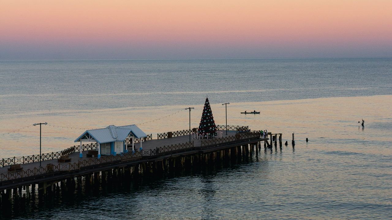
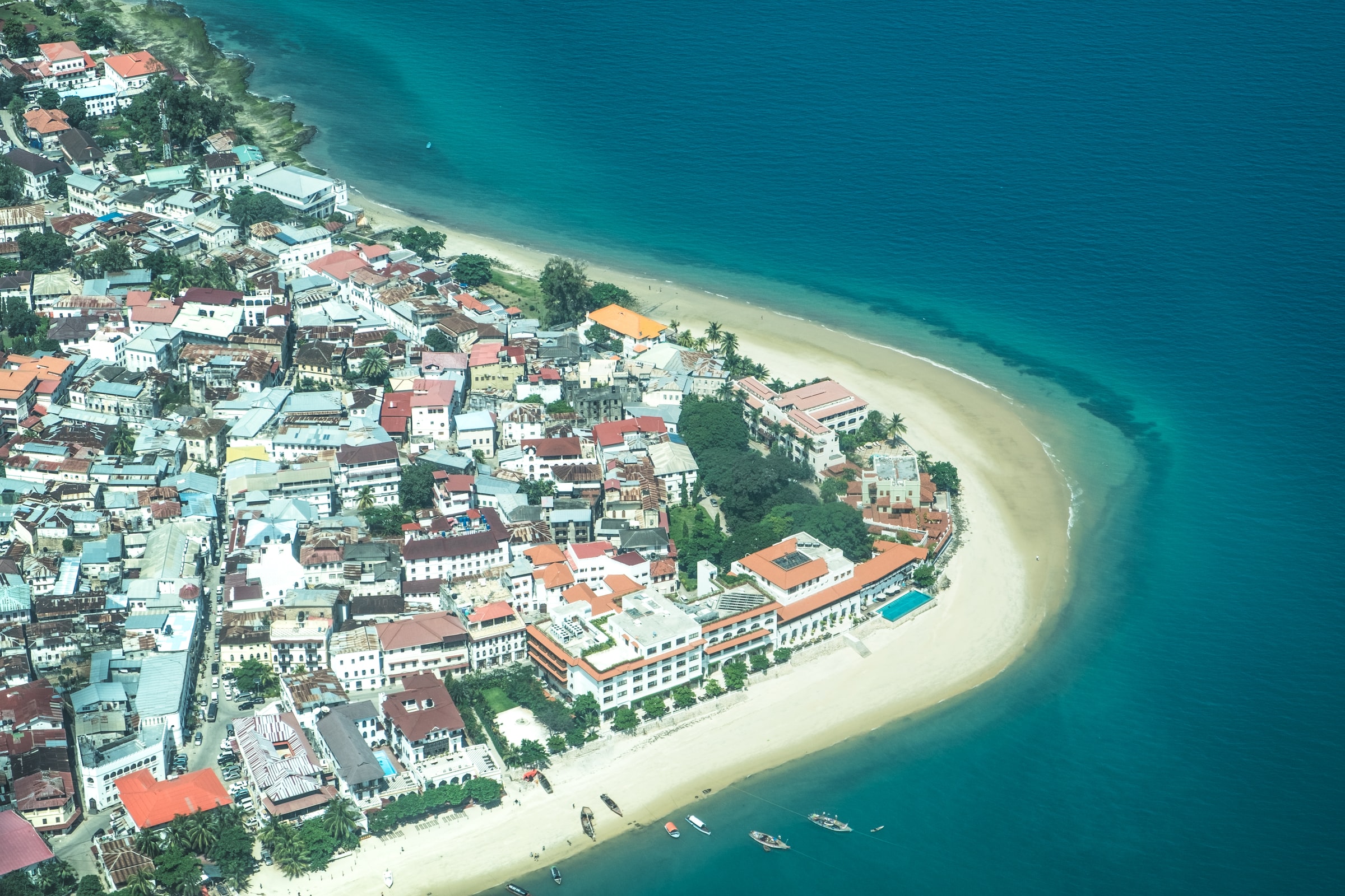
    La Ceiba on the Gulf of Honduras Photo by Alex McCarthy on Unsplash

  • British Columbia in Winter

    British Columbia in Winter

    Okanagan Lake in winter

    British Columbia in winter has a magic all of it’s own, not always sunshine and rainbows but when the combination of elements and weather conditions come together a majesty unfolds and wilderness becomes art.

    There is nothing quite like the “snow crater” that forms beneath Wells Gray Provincial Park’s Helmcken Falls in the winter.

    Helmcken Falls Snow Crater

    Wells Gray Provincial Park was first established in November 1939, which means it just celebrated its 80th birthday.

    The park is home to a beautiful waterfall that flows over a wide circular cliff during the warmer months of the year. According to Tourism Wells Gray, the drop is 141 meters.

    Chasing Iconic Winter Waterfalls of Wells Gray

    Uncover the mystical places that romantics, adventurers and photographers come here to find! With 41 named waterfalls (and counting!), and even more tucked into the wilds, discover why Wells Gray is also known as the land of waterfalls.

    Ancient volcanoes and slow-moving glaciers carved the rivers and lakes that fuel the Park’s waterfalls. You’ll hear the roar of the Falls, long before you can see cascading water tumbling over lichen-drenched boulders, making its way downstream. Almost half the named Falls are found in the Corridor , mere minutes from Clearwater Valley Road.

    Canada’s Waterfall Park Welcomes you in Every Season

    The Land of 41 Named Waterfalls- and counting!

    Imagine a place where the Clearwater, Thompson and Murtle Rivers roar and wildlife sightings are as common as sunrise and sunset. A place where it’s easy to get off the beaten path, and away from the crowds, immersing yourself in real and wild nature.  The place you imagine is Wells Gray Country, the mountain communities centered around Clearwater and Wells Gray Provincial Park. 5,250 square kilometres (1.3 million acres) of alpine wilderness, borne from volcanoes and carved by glaciers. It’s one of the most unique landscapes in all of B.C., where your days are measured in your steps hiked, wildlife sightings, and the number of waterfall shots on your camera. 

    It’s here, among old-growth inland rainforest and soaring mountain peaks that you’ll find your wild. During Spring, Summer and Fall you can hike through ancient forests, paddle pristine lakes, and raft on some of Canada’s fiercest rapids. In the winter, gaze upon frozen waterfalls and ski down untouched backcountry slopes.

    Winter Waterfall Photos by Carlo Borella on Unsplash

  • British Columbia Gold Rushes

    British Columbia Gold Rushes

    Mount Robson, Canadian Rockies

    Gold on my mind lately and learning for the first time about the Omineca Country, also the omineca geology of British Columbia and why the gold rushes happened. The word omineca was used in geology to describe a rift region of land, left behind after dramatic upheaval, followed by millions of years of glaciation and natural climate change.

    Omineca River

    Between the Rocky Mountains and the Pacific ocean lay a landscape that like the palm of your hand, can tell an amazing story, to an expert reader of such things. Terrains are the giant lines that form valleys and rivers, this is where the Omineca country is worn bare by the ions of time. This is where the immense heat was once generated when the earth’s crust, when it was sheared from beneath by eruptions of magma. This is where gold is born.

    British Columbia

    The Omineca Gold Rush was a gold rush in British Columbia, Canada in the Omineca region of the Northern Interior of the province. Gold was first discovered there in 1861, but the rush didn’t begin until late in 1869 with the discovery at Vital Creek.

    There were several routes to the goldfields: two were from Fort St. James, one of which was a water route through the Stuart and Tachie Rivers to Trembleur Lake to Takla Lake and the other was overland, called the Baldy Mountain route.

    A third route came in overland from Hazelton on the Skeena River and a fourth route used the Fraser River and crossed over the Giscome Portage to Summit Lake, through McLeod Lake, and up the Finlay River to the Omineca River.

    British Columbia gold rushes were important episodes in the history and settlement of European, Canadian and Chinese peoples in western Canada.

    The presence of gold in what is now British Columbia is spoken of in many old legends that, in part, led to its discovery. The Strait of Anian, claimed to have been sailed by Juan de Fuca for whom today’s Strait of Juan de Fuca is named, was described as passing through a land (Anian) “rich in gold, silver, pearls and fur”. Bergi (meaning “mountains”), another legendary land near Anian, was also said to be rich in gold as well.

    Speculative maps of northwestern North America published before the area was mapped placed the legendary golden cities of Quivira and Cibola in the far inland northwest. No Spanish exploration parties in search of El Dorado, “the golden one” a reference to the legendary king of a lost golden city, are known to have ever reached British Columbia, although archaeological remains point to a brief Spanish presence in the Okanagan and Similkameen regions of the province’s Southern Interior.

    The Muchalaht, the Nuu-chah-nulth group in the area of the community of Gold River, on Vancouver Island, which is a community at the end of a fjord that drains the west coast of Vancouver Island, tell a story of Spanish arriving then burning the valley searching for gold. Prospectors searching the valley have found old crude dug adits on the pass of the White River Valley and the Gold River Valley.

  • Alignment of Planets to Mark the Fall of Babylon

    Alignment of Planets to Mark the Fall of Babylon

    From the foot of Saddam Hussein's summer palace a Humvee is seen driving down a road towards the left. Palm trees grow near the road and the ruins of Babylon can be seen in the background.
    Hillah, Iraq (May, 29th 2003) — A U.S. Marine Corps Humvee vehicle drives down a road at the foot of Saddam Hussein’s former Summer palace with ruins of ancient Babylon in the background. U.S. Navy photo by Photographer’s Mate 1st Class Arlo K. Abrahamson. (RELEASED)

    Future proves past. Fall of Babylon written in the sky

    How many coincidences before mathematically impossible?

    Anyone who takes an interest in astrology will be aware that we are now experiencing the much heralded conjunction of Pluto, Saturn and Jupiter in the sign of Capricorn. Jupiter was the last to join the conjunction, entering Capricorn in December 2019. Since then, the three planets have been moving closer and closer together and this comes to a head on November 13th, 2020, when they will be lined up within 5 degrees of one another. (This means that they appear to be lined up one behind the other when viewed from the Earth.) The conjunction of these three planets, in the sign of Capricorn, is an extremely rare occurrence. The last time Saturn, Pluto and Jupiter were together in Capricorn was in 1285, at the time of the Crusades. Before that, the previous time they lined up was in 1894 BCE!

    “Entry of Alexander into Babylon”, a 1665 painting by Charles LeBrun, depicts Alexander the Great’s uncontested entry into the city of Babylon, envisioned with pre-existing Hellenistic architecture.
    The Queen of the Night relief. The figure could be an aspect of the goddess Ishtar, Babylonian goddess of sex and love.

    When I mentioned this to a friend, he told me that 1894 BCE might have been around the time of the birth of the civilization of Babylon. Intrigued, I went to Wikipedia and looked up “Babylon” and went straight to a sentence which said: “Babylonia – A small Amorite-ruled state which emerged in 1894 BCE” Wow! Is it possible that in November 2020 western civilization may be completing a great cycle of time that began nearly 4,000 years ago in Babylon?

    Babylon does not get good press in the Bible, but it was here that some of the earliest known sets of laws were created – rules for regulating trade and settling disputes. In those ancient times, the idea of establishing rules to better manage human behaviour was a precursor for the development of the Judaic, Christian and Islamic civilizations that emerged from the Middle East.

    The above 3 paragraphs were from Rebekah Hirsch of Charting the Soul , please read the rest, it’s very important information: 2020, AN EXTRAORDINARY YEAR: THE PLUTO, SATURN, JUPITER CONJUNCTION IN CAPRICORN

    Fall of Babylon photos, maps and allot more information can be found on wikipedia

  • Emerald Tablets and the Halls of Amenti

    Emerald Tablets and the Halls of Amenti

    All day today, for some reason, I had this echoing reminder to post something about the Halls of Amenti, as it’s the most descriptive explanation of a place I’ve been trying to articulate experiences that have occurred to me, on two instances that I was distinctly aware of and very possibly another instance when I drowned and was revived.

    Many accounts in professional psych journals about near death experiences recalling the life review, which is a high speed recollection of happy moments and what seems like a million faces, most of which are your own, through the years. This was named a life review but it’s the place of incredible love and tranquility where you arrive after what seems more like an immense data download into the brain (all of a sudden you know things and the world makes more sense).

    When you arrive instantly you understand that you’ve been there before and it takes some deduction to realize that anything you ask is answered by some form of knowledge conveyance that’s rapid and yet timeless and infinite, connecting to more information and off into infinity. The feeling is peaceful and exciting at the same time as precious and fleeting, since it requires the type of physical calm and environmental perfection that are often difficult to sustain. This is the reason men seek caves to isolate into.

    The Halls of Amenti was described by Edgar Cayce, so it’s no-wonder so many people are still interested to explore this topic. Interesting also to consider the size of the body of evidence that is building, that through practice and conditioning more and more people can experience higher dimensional realms in our own minds.

    Ascension appears to me, the primary purpose of the Emerald Tablets but I’m no expert, just a curious soul, trying to articulate, my own experience.

    The Emerald Tablets – What Are The Halls of Amenti? (from Reddit)

    “Emerald Tablet 2 is about the Halls of Amenti. But what does Thoth mean with the Halls of Amenti?

    There are many speculations what the Halls of Amenti could be. From mystical realms to stargates, or something underneath the Sphinx. Misconceptions are easily born by taking words literally. To transpose them literally from the mystical domain to the material domain is a mistake.

    The Halls of Amenti act as a distortion filter between our physical being and the Soul. It is the realm between the Omega Point and our 3D world. Reincarnation happens from the Halls of Amenti back into a new physical body. This will continue to go on until you finally “get it”, i.e. that the physical world is an illusion.

    The term Omega point (and Noosphere) was first coined by Pierre Teilhard de Chardin, and stands for the highest level of consciousness, i.e. God consciousness.

    The Halls of Amenti, the ultimate hall of mirrors, is the realm of the great illusion that is only passable by knowledge, wisdom, and complete lack of Karma. After passing the Halls of Amenti merger with the Omega Point follows.

    If that idea completely resonates with you, there’s an immense task waiting for you!” Here’s an excellent resource: https://hubpages.com/religion-philosophy/Where-or-What-Are-The-Halls-of-Amenti

    Photo by MAURO VESCOVI on Unsplash

  • Stone Town on Zanzibar the Spice Island

    Stone Town on Zanzibar the Spice Island

    Stone town, Zanzibar

    The name “Stone Town” comes from the ubiquitous use of coral stone as the main construction material; this stone gives the town a characteristic, reddish warm colour. Zanzibar exudes mystique in it’s name and rich history, earning it’s place in our collective mind; as the Spice Island.

    Lady Luck has given me another winning combo with an invitation to participate in the development of a Cannabis Cultivation farm on the Spice Island and naturally to come and swim in the sea and hang-out in Stone Town. I’m beyond thrilled, as you can imagine, since I always wanted to see Africa but never dreamed I’d begin from Tanzania. Thank you Lady Luck.

    Traditional buildings on the island have a baraza, a long stone bench along the outside walls; this is used as an elevated sidewalk if heavy rains make the streets impracticable, or otherwise as benches to sit down, rest, socialize. Another key feature of most buildings is large verandas protected by carved wooden balustrades. The best-known feature of Zanzibari houses are the finely decorated wooden doors, with rich carvings and bas-reliefs, sometimes with big brass studs of Indian tradition.

    Stone Town buildings have two main types of doors can be distinguished: those of Indian style have rounded tops, while those in the Omani Arab style are rectangular. Carvings are often Islamic in content (for example, many consist of verses of the Qur’an), but other symbolism is occasionally used, e.g., Indian lotus flowers as emblems of prosperity.

    Stone Town is punctuated with major historical buildings, several of which are found on the seafront; these include former palaces of the sultans, fortifications, churches, mosques, and other institutional buildings.

    Map of Zanzibar City by Oscar Baumann, 1892

    Oscar Baumann (25 June 1864, Vienna – 12 October 1899, Vienna) – Smithsonian Institution indian-ocean.africa.si.edu

    Photo credit – Javi Lorbada Madrid. javilorbada and by Med J on Unsplash

  • I left my heart in Miami

    I left my heart in Miami

    I left my heart in Miami after the invasion of Iraq in 2003 leaving first for Costa Rica, then Brazil. It seemed ignorant of military history to begin another crusade into Babylon (region) and I felt it hypocritical of myself to voice my opinion, as a Canuck living in Florida, to oppose so strongly the bad idea of invading Iraq, yet remain living there in comfort.

    It broke my heart to leave Miami as a war dissenter but I did.

    Now we know the fraud of WMD’s and have been able to asses the damages to the minds of U.S. soldiers and the loss of good will towards America from the world. Lady liberty lost her lustre and now the people are experiencing the great awakening and learning about the disastrous plans of the Neo-conservatives with their failed theory of the new American century.

    For there is nothing hidden that will not be disclosed, and nothing concealed that will not be known or brought out into the open.

    Luke 8:17

    Deep State bad actors have now been exposed as they attempt to divide America using the Racism tactic. My life in Miami proved to me that racism is just a term used by the media to incite activists and cause divide. South Florida is fabulous for it’s fusion of cultures, if you’re racist you won’t like it because it’s a total melting pot and cultural cross roads.

    Truth is that America loves it’s diversity, look at professional sports those athletes have zero racism and they are a reflection of their sports fans who again have zero racism, AND they represent a perfect example of the exact same attitude across the country.

    I always personally feel (or felt, pre-covid) that America embraces it’s ethnic diversity, celebrates it and promotes it globally. Who doesn’t love the influence that African and Latin American’s have endowed us with. Our complete love of foreign cultures we have willingly adopted, has made us better and better.

    Another good example is Las Vegas, just look around whatever venue you please and notice the interaction among the guests and try to identify racism, you can’t because it’s not there. It doesn’t exist in the workforce either, especially law enforcement, there’s total integration the same as in sports.

    In the real world people coalesce as social friends that share common interest but I will admit that African-American’s do have a tighter natural bond and I often think that they enjoy many benefits and advantages in their brotherhood, however I’ve never felt ostracized or hated but sometimes I knew I was best moving on.

    My life path has had me in every major U.S. city and I lived in Miami for 12 years. When considering people I never make assumptions, or generalizations about any one person based on their ethnicity.

    My experience with Black people in Central, South and North America has been totally positive, and to this day I am blessed to have many as friends, some very close life-long friends. Our souls are the same

    I Left My Heart In San Francisco

    Tony Bennett

    The loveliness of Paris
    Seems somehow sadly gay
    The glory that was Rome
    Is of another day
    I’ve been terribly alone and forgotten in Manhattan
    And I’m coming home to my city by the bay

    I left my heart in San Francisco
    High on a hill, it calls to me
    To be where little cable cars
    Climb halfway to the stars!
    And the morning fog will chill the air

    My love waits there (my love waits there) in San Francisco
    Above the blue and windy sea
    When I come home to you, San Francisco,
    Your golden sun will shine for me!I left my heart in San Francisco
    High on a hill, it calls to me
    To be where little cable cars
    Climb halfway to the stars!
    And the morning fog will chill the air

    I don’t care

    My love waits there in San Francisco
    Above the blue and windy sea
    When I come

    When I come home to you, San Francisco,
    Your golden sun will shine for me!

    YeahSource: MusixmatchSongwriters: D. Cross / G. CoryI Left My Heart In San Francisco lyrics © Colgems-emi Music Inc., Editorial Mexicana De Musica Int. S.a. (emmi), Emi Music Publishing France, Colgems Emi Music Inc, Colgems-emi Music Inc

  • Sweet home Okanagan

    Sweet home Okanagan

    Aaron atop Knox Mountain, Kelowna, British Columbia, Canada

    Sweet home Okanagan title fits so well, borrowed from the famous rock anthem by Lynard Skynard, that it could very well have been written for the place where I grew up; the Okanagan Valley of British Columbia.

    Kelowna 1909

    My family legend is that my father’s grandfather left Salt Lake City in 1888 headed for Vancouver because of political upheaval in Utah and I suspect since he was a young man at that time (born in 1861) he migrated to Canada but on his way to the west coast boom town, he laid his eyes on Okanagan lake from the ridge pass and decided he’d found his new home.

    My father was born in Kelowna as was his father. I was born in Lions Gate Hospital in North Vancouver in 1961 and 100 years after Arthur Day, whose name is inscribed on the Mormon tabernacle in Salt Lake City. Although I live in Vancouver, my heart considers Kelowna my home.

    Kelowna 1920

    Now four generations later the once sleepy valley is home to three mature cities, Penticton, Kelowna and Vernon and the about a half million people that live in a four seasons playground that would be fit for a King.

    The Okanagan Lake is 97 miles long and 2 to 5 miles wide with a large provincial park covering a large swath of land, about in the middle of the lake to encompass the region that surrounds the lake, to preserve and protect that natural wilderness for generations to come.

    Most of the rest of Okanagan Lake has beautiful homes built upon it’s shore and thoughtful urban development has designed subdivisions spread along the mountainsides that gently slope to the waters edge. From a boat the spectacle is remarkable and wonderful to witness the integration of humanity in nature.

    Kelowna (/kəˈloʊnə/) is a city on Okanagan Lake in the Okanagan Valley in the southern interior of British Columbia, Canada. It serves as the head office of the Regional District of the Central Okanagan. The name Kelowna derives from an Okanagan language term for “grizzly bear“.

    The Kelowna metropolitan area has a population of 217,214; the third-largest metropolitan area in the province, behind only Vancouver and Victoria. Additionally, the City of Kelowna is the seventh-largest city in the province. It ranks as the 22nd-largest in Canada and is the largest inland city in British Columbia. Kelowna’s city proper contains 211.82 square kilometres (81.78 sq mi), and the census metropolitan area contains 2,904.86 square kilometres (1,121.57 sq mi). In 2019, it was estimated that Kelowna’s population had grown to 217,229 in the metropolitan area and 142,146 in the city proper.

    Nearby communities include the City of West Kelowna (also referred to as Westbank, Westside) to the west across Okanagan Lake, Lake Country and Vernon to the north, and Peachland to the southwest, and further to the south, Summerland and Penticton.

  • Cameroon and the Bight of Bonny

    Cameroon and the Bight of Bonny

    Cameroon and the Bight of Bonny

    Cameroon and the Bight of Bonny has completely captured my imagination now that I’ve been turned-on to it’s beauty and bounty. Most unique of countries that has been called the “Hinge” of West Africa and I’m sure it’s been called allot of things, since it was once a prized colony.

    Cameroon has the most diverse geography of any country in Africa and often referred to as an Africa inside of Africa because it goes from lush coastal river lowland jungle, all the way up to high dry savanna. Plus, awesome beaches and of course then theirs that Bight of Bonny.

    Cameroon, country lying at the junction of western and central Africa. Its ethnically diverse population is among the most urban in western Africa. The capital is Yaoundé, located in the south-central part of the country.

    Bight of Biafra, also called Bight of Bonny, bay of the Atlantic Ocean on the western coast of Africa, extending east, then south, for 370 miles (600 km) from the Nun outlet of the Niger River (Nigeria) to Cape Lopez (Gabon). The innermost bay of the Gulf of Guinea, it is bounded by southeastern Nigeria, Cameroon, Equatorial Guinea, and northwestern Gabon and receives portions of the Niger and Ogooué river discharges and also the Cross, Sanaga, and many other rivers.

    Within the Bight of Biafra are several islands, the largest of which is Bioko, belonging to Equatorial Guinea. Major ports on the bay are Malabo (on Bioko), Port Harcourt and Calabar (Nigeria), Douala (Cameroon), Bata (Equatorial Guinea), and Libreville and Port-Gentil (Gabon).

    Between the 16th and the 19th century the Bight of Biafra was the scene of extensive slave-dealing operations, based mainly on the ports of Brass, Bonny, Opobo, and Old Calabar (now Calabar) in Nigeria. By the 1830s the palm oil trade had surpassed slave trading, and it has maintained its importance. Petroleum, discovered in the late 1950s in the Niger River delta, is a major economic resource.

    The country’s name is derived from Rio dos Camarões (“River of Prawns”)—the name given to the Wouri River estuary by Portuguese explorers of the 15th and 16th centuries. Camarões was also used to designate the river’s neighbouring mountains. Until the late 19th century, English usage confined the term “the Cameroons” to the mountains, while the estuary was called the Cameroons River or, locally, the Bay. In 1884 the Germans extended the word Kamerun to their entire protectorate, which largely corresponded to the present state.

    Cameroon Photo credit: [phil h] on Visual Hunt / CC BY-NC-ND

  • Sooke, British Columbia

    Sooke, British Columbia

    French Beach , Vancouver Island, near Sooke, British Columbia
    French Beach, Vancouver Island, near Sooke, British Columbia

    The town of Sooke is another place in British Columbia that I have not seen and even though I won’t admit to a bucket list, there are some place I just feel I must go an experience for myself. That being said; Sooke British Columbia is high on the list.

    Sooke’s popularity as a scenic tourist destination has existed for generations. Well-known destinations in Sooke, such as Whiffin Spit Park, the Sooke Potholes Regional Park and adjacent Sooke Potholes Provincial Park attract visitors both locally and from around the world. Sooke is also home to the Sooke Region Museum and Visitor Centre; where visitors and locals are able to get information on regional attractions and history.

    Sooke Basin View by Kiwibirdman
    Sooke Basin View by Kiwibirdman

    The area’s popularity has increased as a base for visiting the wilderness parks of Vancouver Island‘s southwest coast — the West Coast Trail and the Juan de Fuca Provincial Park which includes the now highly popular Juan de Fuca Marine Trail. Sooke, BC is also famous for its beaches just on the outskirts of its neighbouring communities such as Shirley and Jordan River. These beaches include Sandcut, French beach, Fishboat bay, China beach, Mystic beach and more.

    To get an idea of how amazing awesome the beaches are near Sooke, check out this fabulous short video

    The beaches near Sooke, BC in one day

    Back country recreation, or off-road recreation brings a constant stream of 4X4s, quads, ATVs, dirt bikes and home built off-highway vehicles through Sooke as people search out back country access. Hundreds of kilometres of logging roads thread through the hills north of Sooke in the Rural Resource Lands of the Juan de Fuca electoral area, enabling access to several community lakes and small reservoirs. Two large reservoirs, Bear Creek and Diversion, are popular destinations north and west of Sooke.

    Mountain biking is growing in popularity in British Columbia, and Sooke is establishing itself as a destination for the sport. Local advocacy groups such as the Sooke Bike Club are working to have areas such as Broom Hill set aside as parkland.

    The Galloping Goose Regional Trail, part of the Trans-Canada Trail, runs through Sooke and is a popular cycling route to Victoria.

    French Beach, Sooke, British Columbia Photo credit: Nick Kenrick. on VisualHunt.com / CC BY-NC-SA